Maps
 Maps.ppt
Session #1
Big Ideas
Interesting Things to Know about Maps!
1. Maps are drawings that represent a place in the earth as seen from above.
2. People who make maps are called Cartographers
3. Maps are tools people use to identify locations.
4. There are many different types of maps,
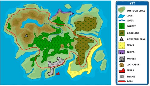
5. Maps use symbols to represent real places and things.
6. Maps show direction by using a compass rose.
7. Maps use a Map Key to describe the symbols places on maps.
Make a Map
1. Cat in the Hat Maps Make a map by clicking below
http://pbskids.org/catinthehat/games/mapthisandthat.html

2. - Making a map of our classroom
http://classroom.4teachers.org/
Maps Use Symbols

Map Maze Game
GeoGames
Race to Build Planet Earth From the Ocean Up!
http://education.nationalgeographic.com/media/geogames/
Label Favorites on the Map
http://mapmaker.education.nationalgeographic.com/
https://www.nps.gov/webrangers/activities/readingmap/readingmap.swf
Build a Map using symbols
http://www.channel4.com/science/microsites/B/buildingthebest/game_city.html
https://www.scribblemaps.com/create/#lat=51.43866924969676&lng=-62.034956216812134&z=3&t=hybrid
Lesson 2 Getting from Place to Place
http://www.maps101.com/static_items/games/uncle_sams_farm_cardinal2.php

http://mapzone.ordnancesurvey.co.uk/mapzone/index.html
Use Arthurs map to get from Place to place
http://pbskids.org/arthur/games/gogeorgego/gogeorgego.html
Are we there yet
https://www.nps.gov/webrangers/activities/mapmatch/?id=15
Challenge
https://www.geovista.psu.edu/grants/MapStatsKids/MSK_portal/Network/index.html
Lesson 3- USA Map Activities
USA Puzzle Game
http://www.abcya.com/USA_geography_puzzle_map.htm
USA Map Activity
http://www.kidsgeo.com/geography-games/united-states-america-map-game.php
States and Capitals Game
http://www.sheppardsoftware.com/USA_Geography/USA_Caps_1_1024.html
Lesson 4 Map Key

http://www.discovertheforest.org/swf/compass.swf
http://www.bbc.co.uk/scotland/education/sysm/landscapes/highlands_islands/flash/land_ms_compass.swf

http://www2.smarttutor.com/player/swf/Geometry_LocationsGrid_L3_V1_t4a.swf
Plot a route
http://www.bbc.co.uk/schools/teachers/ks2_activities/english/activities/deduction.swf
To be able to use a map you need to learn about four things:


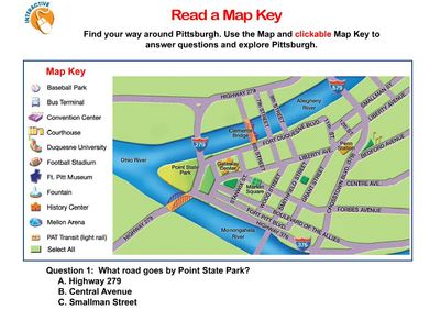
Map key from http://www.bbc.co.uk/scotland/education/sysm/landscapes/highlands_islands/mapskills/symbols/index.shtml#focus
Lesson 5
Types of Maps
Let's take a look at the different type of maps for the state of Michigan
Michigan Physical Map
Michigan Waterfalls Map
Michigan County Map
Michigan Cities and Roads Map
Michigan Rivers and Lakes Map
Michigan Elevation Map
Highest Point in Michigan Map
Michigan Geology News
Michigan Satellite Image
Michigan City Satellite Images
http://geology.com/state-map/michigan.shtml
Scale
Maps can’t show things the size they are in real life so they use scale to make things smaller. Different scales are useful for showing different things on a map.
Let's Practice these big ideas
Let's identify places on a map image of the world at night .
It is taken from space!
Lesson #3
A map is a drawing of a picture of the earth as sen from above.
Can you see the continents on the Earth at Night map
Can you find MIchigan?
Let's look at Earth at Night work sheet.
Can you find the names of the ten large cities highlighted on the work sheet?
Extensions: More Mapping Ideas
Treasure Maps:
Students can also make their own treasure maps.
Literature:
Have students draw a map of the route a character takes in a book. (Little Red Riding Hood's trip to Grandmothers, Hansel and Gretel's journey through the woods, etc.)
What to learn more??
See a resource on the NASA Web site, The Blue Marble. Discuss what features of Earth those other maps show that cannot be seen in the Earth at Night map.
Treasure Maps

http://www.britishcouncil.org/kids-stories-treasure-map-popup.htm
THe Treasure Map Activity
Now that we have studied various types of maps, let's have some fun! Download the map below. Follow the map and you will find a treasure I hid in our school.
Time to use your Map skills in the games below!
 Mystery Island
After finding the treasure, Eric's boat got swept away by tides and storms, eventually washing ashore with the boat broken and the treasure nowhere in sight. The mysterious island he's on hs obstacles blocking his way, and the inhabitants seem to speak in strange symbols. Can you help Eric solve the problems and find a way off the island? PLAY>>>
 Treasure Hunt
Eric's found notes in his grandad's diary about rumours of buried treasure, along with a map of some nearby islnds and a clue on a scrap of paper. But other treasure hunters have now heard the rumours, and a high tide's due to cover most of the area, so time's running out! PLAY>>>
Comments (0)
You don't have permission to comment on this page.